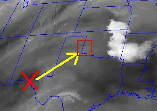
* The image below shows a nice shortwave over SE New Mexico that is heading northeast and should interact with a dryline/sfc front intersection during peak heating today. That will provide both shear and uplift to hopefully break the cap this afternoon and produce some gorgeous supercells in the TX Panhandle. We will be watching closely to see where the dryline and front intersect, as storms that form on the dryline and cross the surface front will have the best potential to produce tornadoes. Regardless, storms that do form will have the chance to produce hail up to the size of baseballs....something we don't really want to deal with :)
* See image below and box that highlights the target area for today...


No comments:
Post a Comment