* Quite an eventful day for the TIG group today. It started by visiting the Carlsbad Caverns just south of Carlsbad, NM. Most of us chose to take the natural entrance which is a nice workout down a steep slope into the cave. I highly recommend stopping here if you are ever in the area!
* After that, we messed around with a storm showing a little rotation. It was a gorgeous storm over the Guadalupe Mountains and brought some nickel sized hail with it. We followed those storms into extreme western Texas before heading back to Roswell
* Our night was finished with pizza and a wonderful exercise plotting a sounding on a Skew T diagram thanks to Dr. Brown. Hand plotting allows students to become a little more intimate with the data and helps to cement the information in their head when reading these charts on computers in the future. Pictures of the day below!
Thursday, May 28, 2009
Tuesday, May 26, 2009
Mesoscale Mayhem - May 26
* We left the comfort of Childress TX and made a nice drive along the Red River to Gainesville. After dropping off our bags and analyzing things, we headed south on I-35 to the western edge of Fort Worth to chase a couple of storms.
* Today's chasing was highly dependent on finding and focusing on mesoscale features such as outflow boundaries and a prefrontal trough. High Instability and Low Shear was the scenario today as less than adequate upper level support left us finding areas where surface convergence was maximized in the unstable environment to create storms. The first storm we found produced a ton of outflow and we intercepted, finding small hail, heavy rain, and gusty winds. That storm split and we decided to chase the left-moving anticyclonic storm as it tracked due north towards higher moisture and lower dewpoint depressions (you don't hear that often!). We moved through the core of that to find some 1.25" diameter hail and fairly strong winds before getting north of that and viewed a shelf cloud at sunset before calling it a night in Gainesville. Not bad for a synoptically poor pattern.
* The remainder of the trip will be classroom and geology based. We'll be spending the next two nights in Roswell, NM and Athena's early forecast is partly stalactite with a chance of stalagmites.
* Here are pictures from today...
Monday, May 25, 2009
Tough Pattern
* Negligible flow aloft has made it hard to pinpoint where storms are going to fire. We targeted roughly the Childress, TX area today and storms tried to develop in an unstable environment. However, a shortwave that kicked off storms in western OK late this morning left our area under the influence of Negative Vorticity Advection and subsidence which squashed the storms in our area in a hurry - negating the decent set up in the low levels.
* After a dinner at the Bobcat Deli and a couple of presentations this evening, we called it a night in Childress before trying it again tomorrow. Early indications are showing the best chase area in the south OK/north TX area near roughly Gainesville TX, but we'll have a better handle on it in the morning.
* After a dinner at the Bobcat Deli and a couple of presentations this evening, we called it a night in Childress before trying it again tomorrow. Early indications are showing the best chase area in the south OK/north TX area near roughly Gainesville TX, but we'll have a better handle on it in the morning.
Sunday, May 24, 2009
Teachers in Geosciences Chase Begins
* Greetings from Canyon, TX, one of the nicest towns in the panhandle of Texas. Today is Day 1 of the Teachers in Geosciences (TIG) field methods course which focuses mainly on storm chasing with a geology component mixed in. Tim Wallace and Athena Owen have joined us as instructors as well as 10 new students from different areas of the country. These students are comprised of middle and high school teachers, USAF meteorologists, and television broadcast meteorologists.
* Day Zero was arrival day for the new students. Once everyone arrived, we enjoyed a hearty meal at Rib Crib where they are celebrating Rib Fest this month...a storm chase tradition. Upon leaving the restaurant, we viewed a severe thunderstorm warned storm that had small hail and gusty winds. The night ended with group introductions and our first forecast discussion
* Day 1 brought us to Canyon, TX after a 3 1/2 hour drive west. We made a pit stop at the Palo Duro Canyon which is the second largest canyon in the United States. Athena taught us some valuable geological information about the canyon and it made for a good time for pictures. So, without further ado....... enjoy!
Thursday, May 21, 2009
On-Campus Chase Wraps Up
*It has been a great chase with the on-campus students. We are in Salina, KS and enjoyed some time this evening reminiscing the great storms and great activities we were able to partake in the last 2 weeks. Tomorrow we'll head to Oklahoma City and the students will head home to Starkville on Saturday.
* As for the instructors, we'll be joined by Tim Wallace and Athena Owen and will begin an 8 day chase with the Teachers in Geosciences group as they wrap up their masters degrees.
* Below is a slide show/video of the events and people over the last two weeks. It was a great group and we are honored that we were able to teach and learn with them this year.
Monday, May 18, 2009
Rocky Mountain High - Colorado
The MSU crew rode into Estes Park, CO on the afternoon of the 17th. After a quick game of mini-golf the group dispersed throughout the town for some snacks and shopping. Upon reconvening we enjoyed a supper of Elk and Buffalo burgers. Today (Monday the 18th) the group packed a picnic lunch and headed into the Rocky Mountain National Park. Within a couple of hours we found ourselves at 11,800 feet above sea level with amazing views of the surrounding mountains. Following our lunch (at 10,000 feet) we descended to approx. 7000 feet where we climbed through an alluvial fan composed of boulders left behind from a 1982 Dam failure. The resulting waterfalls and rapids were spectacular.
The group returned to the park just before sunset where we were greeted by hundreds of Elk and a few Mule Deer. With a few mountain induced clouds still in the area we where treated to quite a sunset. I hope the pictures below can reflect what we where able to see. Not a bad couple of days considering there are no storms!
The group returned to the park just before sunset where we were greeted by hundreds of Elk and a few Mule Deer. With a few mountain induced clouds still in the area we where treated to quite a sunset. I hope the pictures below can reflect what we where able to see. Not a bad couple of days considering there are no storms!
Sunday, May 17, 2009
May 16th Travel Day
The MSU crew left the comfort of McPherson, KS heading west toward the Rockies. Along the way we stopped and the Worlds largest ball of twine and the geographic center of the lower 48 states. We settled in Colby, KS (not named for the husband of one of our students). Colby is the Oasis On The Plains and home of the 2006 NJCAA Region VI Division I Women's basketball champions (I really thought Cloud County would do better that year).


Saturday, May 16, 2009
May 15 Storms
The team left Ponca City, OK heading north into Southeast Kansas in the hopes of getting lucky again on a high instability low shear day. The first storms initialized in Northeast, KS and more quickly grew down the cold front into north-central, OK. We jumped on a storm just north of a break in the line. As we approached the storm reports of tennis-ball sized hail began coming in. We intercepted the storm approx. 4 miles west of Andale, KS. The radar indicated moderate mid-level rotation but the ragged nature of the base of the rotating updraft precluded us from seeing any meaningful signs of an impeding tornado. While none of the storms in Kansas produced a tornado the structure was nice to see.
We are heading into an atmospheric lull so the team will make its way west toward the Rockies. Check back for some different type of nature pics in the coming days.....
We are heading into an atmospheric lull so the team will make its way west toward the Rockies. Check back for some different type of nature pics in the coming days.....
Friday, May 15, 2009
Tornado Video - May 13, 2009
Here is the video from Wednesday's tornado. This is courtesy of Ryan Aylward, an MSU graduate and currently a meteorologist at Weather Data in Wichita Kansas. Ryan joined us for the chase on Wednesday.
Tornado Survey
Good news regarding the tornado we saw on Wednesday - it caused no damage! Because of that, it was rated an EF0 on the Enhanced Fujita scale, which takes damage as an indicator of strength. I am not sure what this would have been rated had it hit something, and quite honestly, I don't want to know... Below is the official results from the NWS - Norman office:
TORNADO - KAY COUNTY OK - 9S NARDIN
654PM-705PM
THIS TORNADO DEVELOPED OVER OPEN COUNTRY 9 MILES SOUTH OF NARDIN AND
REMAINED NEARLY STATIONARY. NO DAMAGE TO STRUCTURES HAS BEEN
REPORTED. THE PRELIMINARY RATING IS EF0.
TORNADO - KAY COUNTY OK - 9S NARDIN
654PM-705PM
THIS TORNADO DEVELOPED OVER OPEN COUNTRY 9 MILES SOUTH OF NARDIN AND
REMAINED NEARLY STATIONARY. NO DAMAGE TO STRUCTURES HAS BEEN
REPORTED. THE PRELIMINARY RATING IS EF0.
Thursday, May 14, 2009
Day 8 (I think)
* It sure is easy to lose track of days out here but today was an off day as we drove an hour and a half south to visit the Oklahoma City Memorial and visit the National Weather Center. The memorial is unbelievable and something I'd highly recommend if you are ever in the area. And the NWC is amazing too. It hosts the OU School of Meteorology as well as the SPC and the NWS Norman office. Neat stuff. We'll try to get some more pictures or video up on the tornado we saw yesterday and will be chasing tomorrow somewhere in Kansas. We'll narrow that down after the morning briefing.
Wednesday, May 13, 2009
May 13 Magic
* A great day for the storm chase team today. We set up in Ponca City and watched storms initiate about 30 miles west of us. We intercepted them early and watched them transition from a high based hailer to a surface based supercell and were fortunate enough to intercept a tornado for roughly 10 minutes. We followed the storm for another hour watching it try to produce tornadoes the whole time. Eventually we left the storm and headed back to Ponca City for the evening. Click through the first pictures below but be sure to check back tomorrow and Friday as we'll add many more to the blog...
Tuesday, May 12, 2009
Tough Day
* Storms did fire today but the shortwave kicked off storms in an area of high spreads between Temperature and Dewpoint which made the storms very high based and mainly hail/wind producers. After hanging out along I 40 in far western Oklahoma, we decided to head back to our hotel in Enid to get some rest for a busy day on Wednesday.
There is hope!
* The image below shows a nice shortwave over SE New Mexico that is heading northeast and should interact with a dryline/sfc front intersection during peak heating today. That will provide both shear and uplift to hopefully break the cap this afternoon and produce some gorgeous supercells in the TX Panhandle. We will be watching closely to see where the dryline and front intersect, as storms that form on the dryline and cross the surface front will have the best potential to produce tornadoes. Regardless, storms that do form will have the chance to produce hail up to the size of baseballs....something we don't really want to deal with :)
* See image below and box that highlights the target area for today...
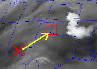
* See image below and box that highlights the target area for today...

Monday, May 11, 2009
Will the cap break?
* Gorgeous Enid, OK is home for the evening as we have the pleasure of staying in the same hotel for two nights in the row. Tomorrow we'll be watching attentively whether or not the cap can break. Several parameters suggest that if a storm can form across western Oklahoma or Kansas, they'll quickly become severe supercells. However, there is very warm air near 700mb that will limit storm development for much of the day. If storms go, we'll be in luck. But there is just as good a chance that they atmosphere stays capped and we'll be left with a sunburn and hopes for a good day on Wednesday in Central/Eastern Oklahoma.
* Today we had a nice drive from McPherson to Enid including stops at a Target and Taco Bueno (Good Taco) in Hutchinson, a post office in a town in Kansas that apparently takes lunch until 1:15, a drive through Greensburg, KS (a somber reminder of the dangers of tornadoes), and a scenic drive down to Enid. See pic below!

* Today we had a nice drive from McPherson to Enid including stops at a Target and Taco Bueno (Good Taco) in Hutchinson, a post office in a town in Kansas that apparently takes lunch until 1:15, a drive through Greensburg, KS (a somber reminder of the dangers of tornadoes), and a scenic drive down to Enid. See pic below!

Plans for Next Few Days
* Good morning from sunny McPherson, KS. Just wrapped up the morning briefing and after analyzing things we've decided to stay on the Plains rather than head to the Midwest for Weds. This will allow us two days to chase (Tues and Weds) and be ready to possibly chase on Friday.
* A rare Day 3 Moderate Risk is in place over Illinois/Missouri, but after checking things out, I get the idea that things will quickly go linear and become a straight line wind event. So we'll hope for supercell storms on the south end in Oklahoma on Weds.
Below is the maps used in the morning discussion with some highlighted favorable things for tomorrow...
Sunday, May 10, 2009
Travel Day
* Day 4 is in the books. We left Sherman, TX, made a recovery mission for a lost ring in Calvin, OK, headed back down Hwy 75 and core punched another elevated hailer before getting on the road. After a phenomenal lunch at Johnny's Original Rib Shack in Guthrie, Oklahoma, we headed up I-35 into Kansas. We are calling McPherson, KS home this evening...a lovely town in the center of Kansas (for the record, it doesn't have a Target).
* Tomorrow will be a decision day for us. We'll be watching the models closely and deciding between heading west to Iowa/Illinois to chase on Weds or staying on the Plains and chasing a little more marginal event on Tuesday and hoping the cap breaks on Wednesday. Check back tomorrow for details on that decision!

* Tomorrow will be a decision day for us. We'll be watching the models closely and deciding between heading west to Iowa/Illinois to chase on Weds or staying on the Plains and chasing a little more marginal event on Tuesday and hoping the cap breaks on Wednesday. Check back tomorrow for details on that decision!

Saturday, May 9, 2009
Hail Yes
* A less than favorable setup for severe weather put us north of the surface boundary today to observe some elevated hailers. These are not tornado producers but can produce marginally severe hail. We encountered this storm near the Red River (OK-TX) border just north of Bonham, TX and saw dime sized hail before heading to Sherman, TX, our home for the night.


Friday Storms
* Yesterday was a game of "wait for the cap to break" as we sat in various parks across southern Oklahoma. Very warm and humid/unstable air built underneath a strong cap and eventually a few storms broke through the cap. We intercepted the first storm about 15 miles north of Ardmore OK to find some small hail and a couple of nice wall clouds including a few brief funnel clouds. The storms were "splitting" which made it a little messy and tough see much visibly, but we did have about 10 or 15 minutes to view the wall clouds below...

(Photo courtesy of Lynssey Myers)


Friday, May 8, 2009
Heading a little south
* Just finished up the morning briefing (charts are below if you care to check it out)...we'll be heading south, somewhere around Ada, OK to set up and wait for the cold front and outflow boundary to kick off storms.
*Remember that you can check out the SPC products and satellite and radar on the right side of the blog!
Today's Charts...
*Remember that you can check out the SPC products and satellite and radar on the right side of the blog!
Today's Charts...
Thursday, May 7, 2009
BINGO
* We made it to Muskogee, OK safe and sound and broke in the van with a nice 8 hour drive. The cap was ridiculously strong this afternoon despite very warm and humid air, so much that we were left with a pretty sunset and no storms.
* But...as is the case on a storm chase such as this, sometimes the off days can provide just as much fun. This year we introduced a game of "Storm Chase Bingo" which you can earn marks in a square for finding various interesting things on the Plains.
Unfortunately, there is no box that says "weird pirate guy holding a large stick in Walmart", but I think it should make for a free mark. Check out this Okie from Muskogee...

We are off!
* Greetings from the road! After a short setback from tailights missing, we are on the road, approaching the bustling metropolis of Winona, MS.
* Today we'll be heading out to eastern OK with a very slim chance of seeing a storm. Anything today is a bonus!
* Tomorrow the SPC has placed a moderate risk of severe storms over south-central Oklahoma with a 45 pct hatched area of severe weather. Should be interesting!
Be sure to use the links on the right side of the page to check radar, tornado potential, satellite, storm reports and current watches!
Wednesday, May 6, 2009
Chase Begins Tomorrow!
* We will be loading up at Hilbun Hall and heading for Oklahoma - departing around 7 AM tomorrow morning.
* Chasing appears possible in Oklahoma or SE Kansas tomorrow and then eastern Oklahoma on Friday before a day off on Saturday. Then we may be back into the action on Sunday as a nice severe weather-type trough sets up over the western US!
* Chasing appears possible in Oklahoma or SE Kansas tomorrow and then eastern Oklahoma on Friday before a day off on Saturday. Then we may be back into the action on Sunday as a nice severe weather-type trough sets up over the western US!
Subscribe to:
Posts (Atom)


