Monday, May 30, 2011

Turn up the Heat

Yesterday was a great day for the TIG Storm Chase group. With surface temps in the mid-upper 90s and dewpoints in the low 60s, we were expecting to see high based storms in an "inverted-V" environment and associated high wind threats. We got on a storm west of Great Bend, KS and immediately noticed the high-based nature of the storm with impressive virga streaks. As we approached the storm, a large cloud of dust formed to our SW from a dry microburst. As the microburst winds approached us, we experienced a 20 degree rise in temperatures in a minute or two from a heat burst. This was a first time experience for all of us and very neat to feel in person.

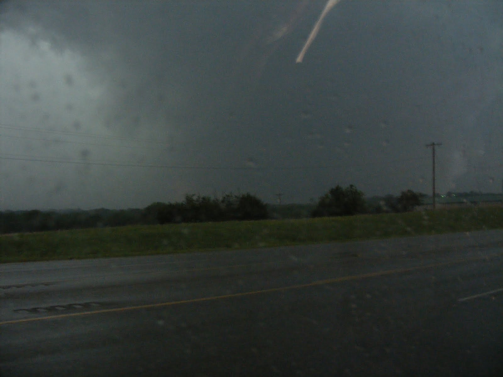
We saw two gustnadoes form along the leading edge of the wind and then moved north to continue chasing the storm. A new updraft formed to our east a few minutes later and followed that for a little while until another very impressive dry microburst occurred with winds estimated between 70 and 80 mph and two more gustnadoes - one of which was quite impressive.

Wednesday, May 25, 2011

Water Not Still

The team left Ponca City for a high risk opportunity in central OK.  The supercells became a bit messy as their cold pools began to merge.  The team then jumped east and intercepted a tornadic supercell just south of Stillwater, OK.  The circulation was wrapped in rain so we carefully positioned ourselves south hoping for a glance.  We were rewarded with a couple of quick looks at the tornado.  We then poked into the damage path to our north (mostly tree, billboard, power pole, and out-building (likely high end EF0 or low EF1 from what we could see)).
Picture taken by student chaser Nathan Owen

Saturday, May 21, 2011

May 20 Storms


It was a fun day for the MSU Chase Team as we departed McPherson, KS and headed west to Belpre, KS to intercept a multi-cell storm that eventually split and weakened. We chose to dive south to a developing storm near Greensburg, KS and followed that as it began taking on supercell characteristics including a weakly rotating wall cloud and nice structure. New storms formed on its southern flank and produced hail in Pratt, KS. We then began our trek south to Enid, OK and had the opportunity to view the storm from 50 miles away as the sun was setting. Overall, a great chase day.


Tuesday, May 17, 2011

Down Time

When we don't have storms to chase, we always try to volunteer our time and help the locals. Yesterday, Matt (our NCAA kicker) put on a "clinic" for the young kickers of east Amarillo. 


Saturday, May 14, 2011

Playing the Waiting Game

Day 2 of the chase featured storms forming in an unstable but weakly sheared environment. Our target was NE Texas and SE Oklahoma and storms began to form about 20 miles north of our location. We intercepted the storm right as it split and began a quick death. From there, we intercepted a second storm that produced dime sized hail near Atoka, OK.

Day 3 was a travel day from McAlester, OK to Amarillo, TX and featured dinner at chase favorite Green Chile Willy's.

Day 4 was spent at Palo Duro Canyon in the morning and about an hour and a half of forecasting as a group for next week's chase prospects.

We have a few more days of forecasting and positioning before chasing begins either Tuesday or Wednesday, depending on which model solution holds the most water.


Thursday, May 12, 2011

MCS Bust

While the early morning departure looked promising but a mystery MCS busted our party.  We ended in Weatherford, OK.  Today looking a bit south in hopes of decent storm.  Then we will have some time off.

Sunday, May 8, 2011

The 2011 Chase Starts Soon

We are making preparations for this year's installment of the Great Plains Storm Chase. We will either be leaving Wednesday or Thursday (more likely Weds). Computer model guidance has been consistent on Wednesday being an active severe weather day followed by a few down days. Whatever the case, we'll be out there ready to go and this site will feature plenty of chase day and non-chase day recaps. Thanks for following along!

Friday, June 4, 2010

Up and Down the Plains

This has been a chase of driving endurance. Early in the week we targeted SE Nebraska for the potential for supercells. During the journey we stopped at a couple of areas known for big things (balls and benches). While storms formed along the cold front the CAP held tight in SE NE. Nevertheless we were treated to some structure and experienced 65+ winds and some small hail. A quick 10.5 hour trip the next day put us in the panhandle of TX where we got to see a dying LP cell. Finally another 9 hour trip to south-central NE rewarded us with a beautiful supercell w/wall cloud and funnel. This cell evolved into a small bow and with terrific structure.

Big Ball


Big Bench


Nice Storm


Sunday, May 30, 2010

A New Chase Begins

The on-campus students departed OKC on Saturday morning and safely made it back to MSU. Saturday afternoon a new group of Teachers In Geosciences students made their way to OKC to begin an eight day field methods course. Today we had our morning weather briefing and positioned ourselves in north-central OK hoping severe storms would form along a cold front and dry line. We intercepted two storms both of which produced severe hail.

Students begin the waiting game with a geology exercise.


Enjoying watching scud being rapidly pulled into the updraft base.

Thursday, May 27, 2010

Coming To An End

The MSU Team spent a couple of nights in Hill City, SD visiting Mt. Rushmore, the Black Hills, and Custer State Park. We then began the journey south toward Oklahoma City where this trip will end. We have seen some incredible storms and great tornadoes. Most importantly we are leaving this trip with more knowledge about severe convective storms.


Today we are driving to Amarillo, TX to see if one of the students can eat 4.5 lbs. of bovine flesh. Check back tomorrow to see if they were successful.

Monday, May 24, 2010

You Just Gotta Have Faith.

This morning the MSU chase team targeted Dupree, SD for the potential for fast moving supercell storms. As we approached Dupree we continued another 20 miles west to setup on the warm front. Storms quickly developed and became severe to our south with the approach of the mid-level trough. The team sat in Faith, SD for approx. 20 minutes watching a severe storm on radar which eventually latched onto the warm front. Within minutes the storm was warned for a tornado. We approached the storm from the north with a large tornado visible at approx. 20 miles away. Continuing south we stop approx. 3 miles from the storm and watched a mature tornado for about 15 minutes prior to the rear flack downdraft occlusion (see video below). The storm briefly weakened and moved north off of the warm front. More video and images will likely be posted. Tomorrow the team will be rewarded with a relaxing trip to Mt. Rushmore and Custer State Park.

Sunday, May 23, 2010

Pictures: May 22 Bowdle, SD Tornado

Here are still images from the May 22nd Bowdle, SD tornado

SD Tornado Again

Below is video from our student Will Simmons.

Saturday, May 22, 2010

Bowdle, SD Tornado 05-22-10

The MSU storm chase team targeted central SD for the potential for supercell storms. As the forcing moved into the region deep convection began to develop and quickly congealed into a single storm. As the storm matured the team positioned itself just ESE of the mesocyclone. The storm quickly produced a rapidly rotating wall cloud and soon a tornado (see video below). The team moved south and east in an attempt to stay with the storm. The tornado became rain wrapped quickly, but we were able to get a couple of more glimpses at it through the evening. More images and video will likely be posted once we have some down time.

Friday Flyover

Friday the MSU team traveled from Garden City, KS to northeastern Colorado. The cap held tight through most of the area and the team did not see any storms. We did however encounter a flyby from a crop duster (video below).

Wednesday, May 19, 2010

May 19 Dover, OK Tornado

The MSU team followed a large supercell for approx. 100 miles across northern Oklahoma. Near Dover OK, the team intercepted the multiple vortex tornado in the video below. The tornado quickly became rain wrapped and chased us out of the area. More images and video to come soon.

Tornado and Funnels

The tornado was brief (just a couple of minutes) but we were able to catch a couple of good images (still image at the beginning of movie below). After the tornado we caught some small funnels which appear to be on the outflow of the storm as they are rotating anticyclonic.


One Storm Many Chasers

Chasers converge on the only storm of the day in the northern TX panhandle. Shortly after this video was taken the MSU crew found their first tornado of the chase.

Day 6 Recap

Today was a fun and successful day for the MSU Storm Chase. We chased a supercell from near Dumas, TX to Stinnett, TX and witnessed beautiful supercell structure including numerous wall clouds, funnels, hail, and the coveted tornado near Stinnett. The students had a chance to also witness an incredible amount of chaser convergence as Vortex 2 and every storm chase group under the moon found themselves on this beastly storm.

We were very fortunate to have a good road to stay just ahead of the storm and also a slow moving storm to give us ample opportunities to take photographs and video.

Below are a few of the shots from our different vantage points today.

The fun doesn't stop today as another outbreak of supercells and tornadoes is expected tomorrow across Oklahoma and far northern Texas. The Storm Prediction Center has placed this area in a Moderate Risk, so we'll be there and hope for another successful day.

Tuesday, May 18, 2010

Day 4 - 5 Recap and Photos

Day 4 took us to Childress, TX where we intercepted multicell and supercell thunderstorms. The first storm of the day was just northwest of Childress and provided some picturesque views of developing updrafts. We left that storm and chased a dieing supercell in far western Oklahoma. After a dinner stop at Pizza Hut (with terrible service), we jumped on another storm that was just a few miles north and east of Childress and followed that for 3o miles and intercepted some hail east of Childress.

Day 5 started out with a journey to Palo Duro Canyon and then out west to Cuervo, NM where we intercepted multicell storms. Eventually, one storm became dominate and began showing signs of broad rotation. This storm was beautiful as we were able to view it from the top of a mesa roughly 5200 ft above sea level. The last two days have been fantastic and we hope you'll enjoy some of the photos below.

The next two days will be active in the Texas panhandle and western Oklahoma.