Saturday, June 8, 2013

On-Campus / TIG Chase 2013

This years combined on-campus and TIG chase was one of the best eight-day chases MSU has had.  The team was chasing a tornado warned storm each of the first six days.  Below are descriptions, videos, and images of our four best chases.

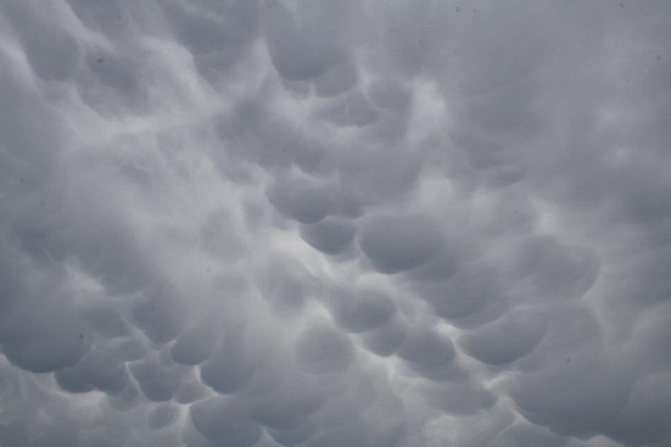
Day one (May 26th) the team left Oklahoma City and headed north into Nebraska.  After a couple hours of park time, storms began to develop just east of North Platte.  The team jumped onto the southern storm and where treated to a visually appealing classic supercell that slowly morphed into an LP storm.

The video above is mislabeled as Kansas.


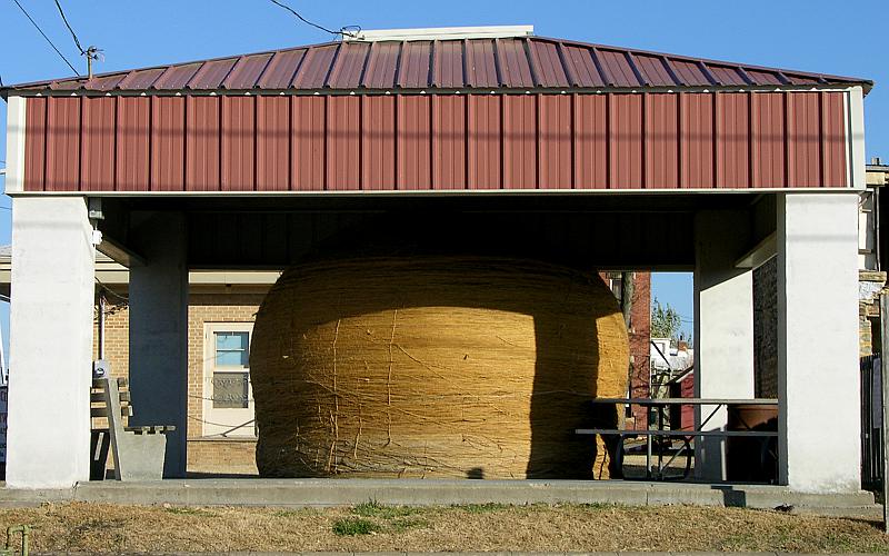
Day two will always be known as the day of big balls.  Prior to chasing we saw the Worlds largest ball of twine.  Storms developed in the late afternoon along the Nebraska-Kansas state-line.  The southern storms became tornadic, but our team was too far south to see the tornado.  After a couple of hours of watching the storm, we poked into the core into see if we could find any hail.  We did.  The largest stone we found was 5.25 inches in diameter, with numerous 3.5 - 4.5 inch stones.

Cawker City, KS

 3 - 4.5 inch stones

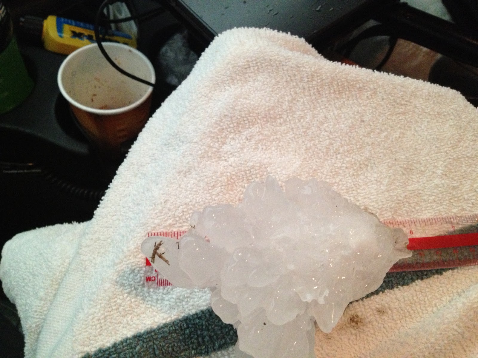
Largest stone found (measured 5.25")


Day three began in Salina, KS and ended in Salina, KS.  After a lazy lunch and a couple hours of park time, a storm formed just north of Salina moving NE.  After 30 minutes of strengthening the storm became stationary and began to produce a short tracked, long duration EF-4 tornado.  Some reports have the tornado on the ground for over an hour, moving only a couple of miles.


 Large nearly stationary tornado

Base Ref. and Velocity Loop of nearly stationary storm.

The last day of chasing was May 31st.  This is an infamous day as many lives where lost including chasers.  The El Reno, OK tornado was initially rated and EF-3, but examination of high resolution mobile radar data increased the rating to EF-5.  The width of the tornado was determined to be 2.6 miles (the widest tornado in U.S. history).  The team intercepted the tornadic storm just south of El Reno, OK.  We watch the amazing rotation in the storm with the tornado apparent in lightning strikes (bottom left of video).

We then drove south and could see the tornado to our west.  The tornado originally was paralleling the road moving south, but then turned east and crossed behind us.
Video says EF-3 (upgraded later)

Once south we could see the now very large tornado to our north.


Wednesday, May 30, 2012

TIG Storm Chase 2012

The 2012 TIG storm chase was fast out of the gate with the theme being HAIL.  The first day in Kansas the group was treated to a large hail-nado (as Tim calls it) with some 1" hail hitting the vans and a much larger ball in Cawker City.  The next day we traveled south to northern Texas where we saw a nice supercell which produced 23 minutes of continuous hail and some delicious rainbows. Our third day found us in northwest Oklahoma with great storm structure and a few hail stones to two inches.  The group is again targeting northwest Oklahoma for our fourth day of chasing.

Hail Shaft
 Big Ball (Not Hail)
 Real Hail
Bows of Rain
Nice Storm
 Nicer Storm 
WOW Cool Storm


Sunday, May 20, 2012

Fire and Ice

Our day started off in Pratt, KS.  We headed to Hutchinson, KS and hung out in a park there for a couple hours.  Storms started to fire to our northwest around 3:00.  We caught up to the storms and got to see some awesome mammatus clouds from the first storm.  We stopped two times just west of Sterling to take pictures with them! 


From Sterling we headed south and found a spot to stop for the next storm near Arlington.  We saw a lot of chasers on the road and one group drove by us yelling "tennis balls"!  The hail markers on radar said 3.5", but it didn't actually get that big.  We ended up seeing hail around golf ball size, the largest we've seen so far!


After the hail, it was tornado time!!  We saw two different tornadoes from the squall line with imbedded supercells.  The first tornado was near Murdock and very straight, long, and skinny.  We only saw it for a little bit before it became rain-wrapped and died.  The second one formed a little south of Murdock.  It was much more defined and impressive.  It had a really strong circulation and was very long-lived.  It lasted at least 15 minutes and kept reforming itself.  There was some debris and dust around the bottom and extending up into the cloud deck so it was easy to see.  We could see it around a wind farm and we later heard that it damaged a blade on one of the wind turbines, but that has not been confirmed yet. 


After those tornadoes, we set up in Danville because we had heard there was another rain-wrapped tornado that was sometimes visible.  We didn't see that one, but we did see some amazing lightning, including some very close to the van.  One nearby strike scared the whole crew and had us piling in the van in less than 10 seconds- record time!  After that we decided we had to move, especially once we started smelling something weird.  It only took a minute to find out what the smell was- the lightning had struck a nearby wheat field and it had caught on fire!  It hadn't spread too much when we drove by and hopefully it was put out by rain soon after.


We headed south from there towards Oklahoma. On our way we happened across a beautiful sunset as the sun dropped below the cloud bases.  We all got out of the van to watch it set, take pictures, and enjoy the beautiful sight before getting back into the van and heading to Perry, Oklahoma.  What a way to end our journey! 

Thursday, May 17, 2012

From Canyons to Oz

Wednesday we woke up in Amarillo and went to Palo Duro Canyon.  It is the second largest canyon in the United Sates, after the Grand Canyon.  Its name translates to 'hard wood', after all of the Mesquite trees that are found there.  To quote Georgia O'Keeffe,  "It is a burning, seething cauldron, filled with dramatic light and color".  It gets as deep as 820 feet in some areas.  We went to the visitor's center to get some information and take pictures from the top of the canyon.  We then got to drive down into the canyon, through water crossings, bushes, cacti, and camping areas.  


After a delicious lunch at Fat Boys (it has its name for a reason), we headed west of Amarillo to Cadillac Ranch.  It is an art exhibit in the middle of a cattle field consisting of 10 Cadillacs stuck halfway into the ground and meant to represent the angle of the Great Pyramid of Giza.  They were moved to their current location in 1997 and the cows seem very happy with the arrangement, as cow pies were prevalent surrounding the sculptures.  There has been graffiti accumulating on the cars since they were set up and we felt the need to add our own contributions: "MSU Storm Chase 2012" and "8 students came to Amarillo to storm chase.  We didn't find any storms, but we did find Cadillac Ranch.".


We went to the famous Big Texan Steakhouse for dinner, home of the free 72 oz. steak.  A total of 5 people attempted it while we were there- and they all failed.  Most of us ended up with  the Man vs. Food special- 18 oz. steak, rolls, baked potato, and salad- that's a lot of food!  Plus 3 deserts around the table.  Everything is bigger in Texas- especially the meals!
This morning we headed north from Amarillo through the panhandles of both Texas and Oklahoma to get to Garden City, Kansas.  Along the way, we stopped in Liberal, KS, the home of Dorothy's House and the World of Oz.  We spent some time playing on the kid's playground before joining a small tour through the house and Oz land!  The tour guide was a young girl who basically reenacted the movie as we moved through a building containing replicas of movie scenes.  We also visited the saddest Subway in the world- we don't recommend that part of the trip.


Storms were developing to our northwest when we left, so we went after them.  We found an area on the edge of a huge wheat field to park and watch the storms move across the area.  The winds were really strong- playing frisbee was impossible.  Evaporative cooling allowed for dense air aloft to descend, creating strong downbursts, which helped create gustnadoes on the leading edge of the downburst.  There were at least 4 or 5 that passed through our area, making the wind even stronger and whipping dust around the area and eventually mixing with very cold rain.  While the storms were shallow with high-bases and low-tops, they were prolific wind producers.  The Radar image below shows numerous fine-lines indicating horizontal rolls.  These horizontal tubes can be pushed into the vertical with strong outflow winds creating brief gustnadoes as seen below.


We managed to get on the other side of the storm so we had a great view of the lightning as the storm passed us again.


Tuesday, May 15, 2012

West Texas Chill

After waking to a cold rain in Roswell, NM the group heading south to the Big Bend region of Texas.  The rain and storms migrated south as well crushing the warm sector, which we hoped would bring us a shot, albeit small, for a tornado.  The shear was good, but the cold air won the battle reducing the low-level instability.  A couple of small storms made their way to our area, but quickly collapsed.  The decay stage of the storm below, did provide us with 10 minutes of small hail, and some nice views as it moved through the mountains.